
Facilities on the Watershed
Deposition Monitoring Network
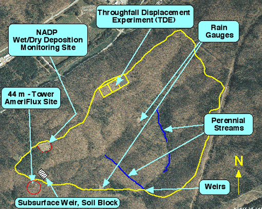
Walker Branch Watershed was part of the National Atmospheric Deposition Program/National Trends Network deposition monitoring program (1980-2011). The purpose of the network is to collect data on the chemistry of precipitation for monitoring of geographical and temporal long-term trends. Wet deposition collectors were used at Walker Branch Watershed to collect precipitation for analysis of trace metal and major ion chemistry since 1976. National Atmospheric Deposition Program NADP/NTN Monitoring Location TN00
Meteorological Tower
The NOAA ATDD deciduous forest meteorological research site was located on the western border of Walker Branch Watershed at an elevation of 365 m above msl. Research facilities at this site include a 44-m tall stairway tower and two 33-m triangular towers that serve as head and tail spars for an instrument support system. The instrument support system consists of eight parallel pairs of cables mounted at seven levels within and one level above the forest canopy. This system allows measurements in planes parallel to the forest floor using a moving sensor mounted on the cable system. This tower was deactivated in 2007 following a lightning strike that destroyed instrumentation. It was replaced by a tower located approximately 5 km to the southwest (AmeriFlux).
Subsurface Weirs
Facilities for the study of hydrogeochemical transport through soils included an isolated soil pedon (2 x 2 x 3 m deep) and a subsurface weir. The soil pedon was instrumented with soil solution samplers at nine depths. The subsurface weir system consisted of a trench (approximately 13 m long and 2.5 m deep) that intercepted flow from a 0.45 ha subcatchment. Stainless-steel pans on the upslope face of the trench intercepted subsurface hydrologic flow from the A, E, and Bt1 horizons and the Bt2 and Bt3 soil horizons. The subsurface and surface flow was routed through a tipping-bucket rain gauge linked to a computer data acquisition system.
Weirs
Stream gaging stations located above the confluence of the two forks (East Branch and West Branch) of Walker Branch consist of 120 degree V-notch weirs. The 2.5 foot deep V-notch in each weir is capable of measuring maximum flows of 41.6 CFS (1.18 m/s). A sharp-crested rectangular section above the V-notch extends the upper flow limit to 65.7 CFS (1.86 m/s) with slightly less accuracy. Flow seldom exceeded 24 CFS (0.68 m/s) so the accuracy of normal stream flow measurements was quite high.