This was a distributed, field measurement campaign in support of the GEWEX-GCIP 1998-99 Large Scale Area initiative.
The Global Energy and Water Cycle Experiment (GEWEX) established by the World Climate Research Program, and the GEWEX Continental Scale International Project (GCIP) worked to improve our understanding of the interactions between the atmosphere and land surfaces, and to incorporate this knowledge into coupled hydrologic-atmospheric models for better climate and hydrologic flow predictions. The GCIP project was undertaken because of a recognized inadequacy of current model representations to simulate the processes coupling the land and the atmosphere, and because of limited information from which to validate model outputs. Major GCIP objectives included: (1) development and validation of macroscale (> 106 km2), mesoscale (103 to 104 km2), and coupled hydrologic/atmospheric models, (2) to develop and validate data gathering schemes that coordinate satellite remote sensing and enhanced ground based observations, and (3) to translate future climate change into scenarios for impacts on water resources and temperature on a regional basis.

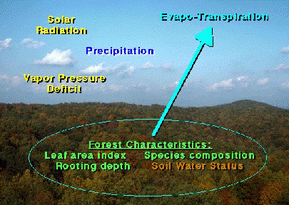
This multi-site study was established in early 1998 to estimate the contribution of closed-canopy forests to local and regional hydrologic budgets in the Ohio Tennessee River watershed. Six upland sites were instrumented for continuous, monitoring of climate variables, soil water conditions, tree transpiration, and soil surface evaporation throughout the 1998 and 1999 growing seasons. The sites, located in Tennessee, West Virginia, and Indiana, were distributed across known regional gradients of precipitation, temperature, and soil water holding capacity to facilitate a broad interpretation among sites and tree species. All atmospheric, soil and tree-based measurements were collected at hourly intervals. The measurements were being used to derive mechanistic relationships between forest water use, climate, and soil water availability. Species-specific measurements of individual tree sapflow velocity were scaled to the plot level proportionate to a species’ contribution to total stand sapwood area. Direct estimates of transpiration based on sap flow measurements made this approach unique from other modeled or remotely sensed methods. Litter layer evaporation was measured independently. Seasonal and daily patterns of evapotranspiration were related to empirical and mechanistic models of atmosphere-soil-plant hydrologic flux with an emphasis on understanding critical soil water contents responsible for driving biological limitations of forest water use. This research provided critical, multi-year data on temporal and spatial dynamics of terrestrial evaporation, transpiration and multi-depth soil water dynamics for upland forest ecosystems.

Primary objectives:
- Provide direct measurements and a quantitative, mechanistic description of deciduous hardwood forest transpiration for representative forest stands throughout the Ohio-Tennessee river watersheds.
- Derive mechanistic relationships between total canopy conductance and environmental variables, and test models of atmosphere-soil-plant hydrologic flux.

Funding for this project was provided by the Terrestrial Ecology Program, Earth Science Enterprise, National Aeronautics and Space Administration, (NASA’s Earth Science Enterprise) as a part of the Joint Program on Terrestrial Ecology and Global Change.
